|
Route taken (Click on the links below for an expanded
description of the trails & hikes)
Click
On Picture To Enlarge
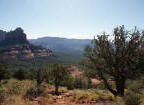
Trail to Submarine Rock
New trails now allow an alternative route to
avoid hiking along roads. Two paths back to the Broken
Arrow Parking Lot are Possible. Each starts at the Hog
Wash - Mystic Trail Junction after hiking the Hog Wash Trail for 0.4
miles. View Trail Map
1) Hog Wash Trail will take you back to
Broken Arrow Trail and from there a short hike to the parking
lot.
2) Or After hiking Hog Wash Trail for
0.6 Miles it will joing with Hog Heaven Trail. Hog Heaven
can be taken to Twin Butte Trail which will then Broken Arrow
Trail. From there it is just a short hike to the Broken
Arrow Parking Lot.
|